UAV-based inspections are becoming increasingly commonplace in the energy and industrial manufacturing industry. Fueled by the evolution of drone hardware, sensor technology, and the expansion of Beyond Visual Line of Sight (BVLOS) certifications, the use of drones has become standard practice for performing applications such as oil well and tank inspection, pipeline inspection and monitoring, and safety and compliance inspections just to name a few.
And you don’t need to look far to see the immediate benefits UAV inspections are yielding:
Increase Worker Safety
Drone-based utility inspections take Inspectors out of dangerous environments such as elevated, confined space and hazardous conditions. Inspectors and field crews are able to perform more frequent inspections while increasing overall safety.
Cost Savings
The time and expense to perform those elevated inspections are significantly reduced simply by putting drones to use in those applications, especially where expensive scaffolding or asset shutdowns are required.
Faster And More Accurate Data Catpures
Drones and robotics coupled with the right sensors provide large amount of inspection data. When combined with Beyond Visual Line of Site (BVLOS) capability, organizations can perform more frequent inspections in a shorter amount of time compared to manual inspections.
With those benefits in mind, its obvious UAV-based inspections will continue to expand. However, these applications are only scratching the surface in terms of the possible benefits of UAV-based inspections. The secret to unlocking the power of your UAV program and going beyond the images is the intelligent use of all that collected visual data!
What We Will Cover:
- How to best manage your collected visual data
- How to operationalize that data
- The best data collection practices
- The best asset analysis practices
- Putting it all together
Insights Beyond The Data
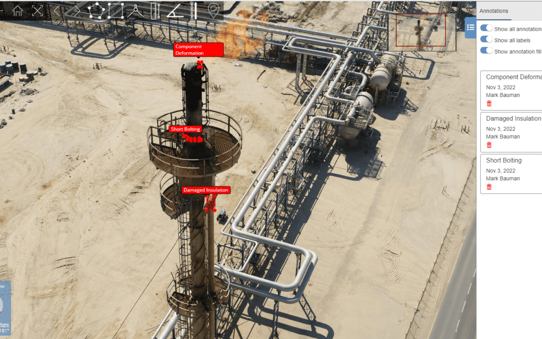
Drone-based inspections yield massive amounts of high-resolution images and videos as well as other data sources like LiDAR, thermal and methane detection.
This data is key to critical inspection decision making. However, it is only through the effective management, collaboration and analysis of this data that sustainable improvements and breakthroughs are possible.
A common statement expressed by a number of senior energy and industrial manufacturing company leaders, who remain skeptical about the true benefits of broad UAV inspection deployments is “I see lots of great pictures of our assets, but I’m not sure we’re seeing return on the investment.”
The most common challenges companies face in realizing maximum return on their drone programs investments are:
Wasted Data
Drones are being used to collect vast amounts of visual data for asset inspection, but a high percentage of the data does not appear to be useful or often times goes unused.
Lack of Data Integration
Images, 2D and 3D models and Digital Twins are being generated but often times not integrated into a comprehensive view of the asset, reducing the effectiveness this data and the ability to identify asset conditions.
Limited Insights
The data collected is not being utilized to its full potential to provide contextual relationships between the visual data and the root cause of the problem.
Data Silos
Drone inspection data exists in a silos, making it difficult to use in conjunction with other data sources to create a more comprehensive view of the assets.
Difficult to Collaborate
Ineffective communication across stakeholders and organizations. For example, Mitigation teams do not have full access to the drone inspection data to improve time to repair.
Energy and Industrial manufacturing companies are looking to overcome these challenges. They want to go beyond the pictures and achieve meaningful results from their drone program.
This means using images and videos alongside 3D models, maps, panoramas, CAD drawings, and other documents. When implemented properly, this allows users to better see relationships to other data which is critical to driving maximum value and insights.
Let’s look at the basic capabilities that need to be in place for any UAV-based inspection program to generate the highest return on investment and overcome these issues.
Intelligently Store and Manage Massive Datasets
This means creating a single source of truth to allow data to be processed, correlated, easily accessed and shared across the organization.
One of the most critical issues is properly geolocating all of this data so that it can ultimately be used to create a complete view of the specific asset, so that proper identification and mitigation actions can be performed.
Integrated Data Visualization
Organizations must provide all stakeholders with a way to visualize and act on all this data, including complex 3D models, maps, panoramas, videos, and other formats, all in a single location. This eliminates the need for disparate systems to view and analyze that data.
The power of the data lies in the ability of the organization to securely and effectively use it to solve problems. This means making the data accessible to inspectors, site managers, 3rd party contractors, EH&S personnel and others who can use it to their advantage.
Operationalize the Data
This is perhaps the most important step. Operationalizing the data ensures it is being used to identify and solve asset performance, reliability, inspection, or EH&S problems.
The ideal workflow is one that uses the collected data to automate or streamline a specific process. Then, through the analysis process, specifically identify service impacting, asset degradation, safety or inspection issues that need to be addressed.
The final step in the process is dispatch or trouble ticketing, providing the geolocated data required, so that mitigation crews can quickly resolve issues.
When combined, these three elements represent a process that looks like this:
- Ingest and manage all the data associated with your UAV Program in one place
- Provide the necessary visualization and analysis capabilities so that all stakeholders can access and utilize it to drive real outcomes.
- Operationalize the end-to-end workflow by providing the right data to the right person at the right time and place so that rapid trouble resolution can occur.
Implementing these elements will provide the basis of a UAV program that can generate real operational improvement, reduce inspection costs and improve overall safety for years to come.
Implement Best Practice to Achieve Optimal Results
Once a robust visual data management system is in place, the focus now shifts to ensuring that a series of best practices are in place, to deliver optimal results and repeatability. Following these steps will ensure optimal results for whatever your specific use case might be.
Download the complete version of this whitepaper to uncover additional insights, including a more detailed step-by-step implementation with real-world examples.
Download Whitepaper
“8 Ways to Optimize Drone Asset Inspections:
Optelos Puts Together Lessons Learned from Enterprise Clients”
