Optelos is at the forefront of revolutionizing the utility sector with cutting-edge aerial drone inspection services. By harnessing advanced drone technology, Optelos offers precise, efficient, and safe solutions for utility inspections, transforming how powerlines, pipelines, and infrastructure are assessed and maintained. This innovative approach not only reduces risk and costs associated with traditional methods but also enhances accuracy and timeliness in data collection. Optelos empowers utility companies to make informed decisions swiftly, ensuring seamless operations and reliability. Discover how Optelos is reshaping the future of utility inspections with superior aerial drone solutions.

Aerial drones enable inspection of infrastructure located in heavily wooded areas that would be difficult to accomplish with ground-based methods.
The Rise of Aerial Utility Inspections: Transforming Infrastructure Inspections
The advent of aerial inspections has significantly transformed how utility inspections are conducted. Drone inspections, coupled with UAS solutions, offer a revolutionary approach to infrastructure inspections. Traditional inspection services involved lengthy and labor-intensive processes, but drone technology has streamlined this with its precision and efficiency. Inspectors now harness the power of drone inspections to perform comprehensive utility inspections, allowing for a broader scope of infrastructure assessment. By integrating aerial inspections into their methodology, infrastructure inspections are more accurate and less intrusive. Utility inspections benefit greatly from this technology, as aerial inspections identify potential issues quickly and effectively. With drones, inspectors can effortlessly cover large infrastructure expanses, ensuring thorough evaluations and timely intervention when needed. As industries continue to embrace aerial inspection services, the utility sector finds itself at the forefront of a technological revolution, representing a substantial shift in how inspections are executed and infrastructure health is maintained.

Advanced Aerial Inspection Capabilities for Utility Inspections
With advanced aerial inspection capabilities, Optelos is at the forefront of transforming utility inspections. Utilizing cutting-edge technology and drones, our asset inspection services enhance the effectiveness of surveying utilities and infrastructure. By employing unmanned aircraft systems (UAS) solutions, we ensure seamless asset observation, offering an unrivaled perspective for utility inspections. Our services provide a generation of high-quality data that supports efficient infrastructure assessments. The deployment of drones allows for rapid and comprehensive aerial inspections, reducing the time typically required for traditional methods. This approach not only improves safety but also maximizes coverage of critical utilities. Our technology-driven solutions set new standards in asset management by offering precise and accurate insights. As the demand for reliable utility inspections increases, Optelos remains committed to delivering innovative services. By adopting our aerial inspection capabilities, organizations can significantly optimize their operational efficiency and maintain robust infrastructure monitoring.
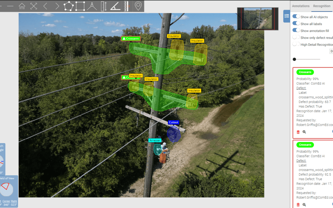
Automating Aerial Power Line Inspections with AI/ML: Enhancing Utility Inspection Efficiency

In the ever-evolving landscape of utility inspection, Optelos is at the forefront of leveraging drones and AI/ML technology to automate aerial power line inspections. By incorporating drones into the inspection process, utility companies are revolutionizing the way they conduct power line inspections, increasing efficiency and accuracy. These aerial inspections allow for comprehensive visual data collection that can’t be matched by traditional methods. The integration of AI and machine learning further enhances this by rapidly analyzing data, identifying potential issues, and delivering actionable insights. Asset inspection becomes more precise, reducing the risk of outages and improving service reliability. By automating inspections with innovative technology, utilities can streamline their processes, ultimately transforming the approach to utility and asset inspection. Optelos ensures that the data captured is not only abundant but also highly relevant, empowering companies to make informed decisions. Welcome to the future of utility services, where inspections are smarter and more efficient.
Optimizing Overhead Line Inspections for Utilities
In today’s fast-evolving energy sector, optimizing overhead line inspections for utilities is pivotal. Leveraging Optelos’ advanced aerial capabilities, utility companies can effectively manage their power lines and utility assets. The integration of aerial drone inspections revolutionizes the way utility assets are inspected, combining IR and visual inspection technologies to deliver accurate data quickly and efficiently. As infrastructure ages, regular inspection of power lines becomes indispensable for utilities to ensure the stability of their energy resources. The ability to inspect from above with high-resolution camera systems enhances the precision of identifying potential issues in utility assets. Aerial inspection not only reduces downtime but also enables efficient management of critical infrastructure, allowing organizations to strategize resource allocation effectively. Bringing data back efficiently and securely, these aerial drone inspections with Optelos highlight a transformative shift in how overhead line inspections are conducted, ensuring that utilities maintain optimal service while safeguarding valuable resources.
Aerial Vegetation Management: Revolutionizing Aerial Inspections with Drone Technology
Vegetation management is vital for utility infrastructures, and aerial inspection using drone technology is transforming how utilities handle this task. Drones equipped with infrared imaging and visual data capabilities provide comprehensive insights into vegetation conditions around utility structures. With advanced drone infrared systems, utilities can detect potential vegetation threats before they impact the infrastructure, ensuring more precise inspections. Leveraging drone technology, utilities can optimize their resources effectively, reducing the need for manual inspections. As these drones collect valuable data, the analysis of this information allows for more strategic vegetation management. Training programs are essential for personnel to maximize the use of aerial inspection services. By integrating drones into vegetation management, utilities can enhance efficiency and maintain infrastructure reliability. Optelos provides a suite of advanced services that harness the power of drone technology, offering innovative solutions for aerial inspections and vegetation management in the utility sector.

Comprehensive Infrastructure Inspections: Ensuring Accurate Vegetation Management
Comprehensive infrastructure inspections are paramount for ensuring accurate vegetation management in utility inspection processes. With the rise of drone technology, inspections have evolved, offering unmatched visual and infrared (IR) capabilities essential for optimized infrastructure assessments. Utility inspection services now leverage state-of-the-art drones, equipping operators with advanced visual and IR camera tools to capture high-resolution data. These inspections empower utilities to maintain precise vegetation management, thereby enhancing the reliability of infrastructure. As drones rapidly transform the landscape of utility inspections, services provided by Optelos enable precise data acquisition, ensuring vegetation doesn’t compromise utility operation. This capability highlights the importance of a meticulously planned management strategy to protect infrastructure integrity. Drones play a critical role, delivering efficient, reliable, and comprehensive inspections. Through these advancements, Optelos’s infrastructure inspections significantly improve operational safety, efficiency, and insight into utility health, underscoring the value they add to modern vegetation management and overall infrastructure resilience.
In conclusion, aerial drone inspections are revolutionizing the utility sector by providing precise, efficient, and secure solutions for asset management. By leveraging advanced technologies, Optelos enables utility companies to gain unparalleled insights, reduce operational costs, and enhance safety measures. As the industry continues to evolve, adopting aerial drone inspections will be imperative for utilities seeking to optimize their infrastructure maintenance strategies. Trust Optelos to support your utility inspection needs and drive significant operational efficiencies. Join us in transforming your utility inspections with the pioneering capabilities of aerial drones.