Oil and gas drone inspection offers cost and safety advantages, but requires thoughtful data management
In the oil and gas industry, asset inspections have often presented significant organizational challenges. While asset inspections are essential, they can be dangerous, and are typically difficult to manage and accurately complete with increasingly scarce skilled personnel. Traditional inspection methods, while time-proven, often grapple with safety considerations, skilled inspector availability, and the sheer scope of the resources required to complete the task. Enter the age of technological evolution, and the industry finds itself on the cusp of a transformative shift—embracing the unparalleled potential of oil and gas drone inspections.
Unmanned aerial vehicles (UAVs) are utilized extensively for inspecting pipelines, oil rigs, and vast stretches of infrastructure, promising not only a bird’s-eye view of these critical assets, but also unprecedented detail, safety, and efficiency. No longer are inspections just about gathering operating metrics, prescribed measurements and evaluating corrosion levels; with drones, the amount of information gathered provides data-driven insights, real-time evaluations, and cost-effective results. In this exploration, we delve into the rate of adoption of drone inspections in the oil and gas sector, weigh their benefits against traditional methods, identify potential pitfalls, and spotlight how platforms like Optelos are amplifying the value of drone-collected data.
Oil and Gas Drone Inspection Gaining Industry Adoption
The oil and gas industry is a highly competitive environment that is constantly seeking innovative solutions to streamline processes, enhance safety and reduce costs. Drones, or Unmanned Aerial Vehicles (UAVs), have emerged as an adaptable and useful tool for achieving these goals. But how rapidly have they been adopted, and what does the landscape look like currently? Let’s dive into the numbers and trends.
Historical Context
The connection between drones and the oil and gas industry began around the early 2010s. Initial engagements were cautious, with drones deployed for simple surveillance tasks, such as creating site maps and aerial imagery. However, as the technology matured, so did its applications, ranging from pipeline monitoring to flare stack inspections.
Current Statistics
As of Q1 2023, an estimated 16% of major oil and gas companies globally have integrated drones into their visual inspection protocols, with another 74% indicating an intent to integrate drone inspection into their programs in the future. This significant number speaks volumes about the industry’s belief in the value of UAV technology to augment their visual inspection programs. Smaller companies and contractors have also begun to recognize the value, with a rising trend in adopting drones for specialized tasks, although most of the early adopters are larger enterprises. Drone inspections augment visual inspection, and the main reason cited for visual inspection is increasing site safety (98%), followed by operational reliability (66%) and addressing regulatory requirements (29%).
Regional Adoption
North America, particularly the U.S., leads the world in drone adoption, elevated by technological advancements and a regulatory environment that’s increasingly supportive of UAV operations. European markets follow closely, with the North Sea operations standing out as a hub of drone activity. Meanwhile, the Middle East, with its expansive oil fields, has also seen a surge in drone usage, particularly for monitoring remote locations. The higher costs associated with visual inspection in North America and Europe is the main driver for oil and gas drone inspection adoption, as 74% of companies state that their main challenge in conducting more visual inspections is budget and resource availability. Drones address both of these issues particularly well.
Future Projections
With the undeniable benefits that drones offer, their adoption rate is expected to accelerate over the remainder of the decade. Industry analysts predict that by the end of the decade (2030), nearly 90% of oil and gas companies will rely on drones for some form of inspection or surveillance. As technologies like AI and advanced imaging become more integrated with drones, their capabilities and applications within the industry will further expand.
Industry analysts predict that by the end of the decade (2030), nearly 90% of oil and gas companies will rely on drones for some form of inspection or surveillance.
The rate of drone adoption in the oil and gas sector is not just a testament to the technology’s capabilities but also an indicator of the industry’s forward-thinking approach. Embracing change, prioritizing safety, and optimizing operations are at the core of this shift, and drones are at the forefront, revolutionizing how asset inspections are conducted globally.
Advantages of Drones Versus Conventional Inspections
The world of oil and gas, with its sprawling assets and intricate systems, demands rigorous inspections to ensure safety, operational efficiency, and regulatory compliance. While traditional methods have served the industry for decades, the emergence of drones presents a new paradigm of benefits that can’t be overlooked. Let’s explore these advantages in detail.
Safety
One of the paramount concerns in the oil and gas sector is ensuring the safety of its personnel. Conventional inspection methods often require individuals to navigate dangerous areas, work at elevation, or even work amidst hazardous gases, corrosive liquids or high-pressure lines. Drones eliminate these direct human exposures, allowing for inspections in even the most challenging and hazardous environments without jeopardizing human safety.
Efficiency and Speed
Time is a critical factor in the oil and gas sector, especially during planned outages or maintenance schedules. Drones can cover vast stretches of pipelines, offshore rigs, or storage facilities in a fraction of the time that conventional methods would demand. Cooling towers, flare stacks and other vertical equipment can be inspected without the need to construct scaffolding. This speed ensures minimal downtime, leading to enhanced productivity and eliminating lost production time.
Precision and Detail
Armed with high-resolution cameras and advanced sensors, drones capture intricate details, often missed by the human eye. Whether it’s a hairline crack on a pipeline or early signs of corrosion on an offshore platform, drones provide comprehensive visual data, ensuring that no detail is overlooked.
Cost-Effective
Conventional inspections often involve significant expenses, from deploying specialized equipment to scaffolding setups and, sometimes, even halting operations. Specialized inspections may require sending specifically trained personnel to remote locations to conduct inspections. Drones, on the other hand, can operate at a fraction of these costs, collecting detailed, high-resolution imagery and sensor data that allows the limited inspection resources to conduct their analyses remotely, allowing fewer people to cover a larger area, and reducing or eliminating time-consuming and expensive travel to remote locations.
Environmental Impact
As industries globally grapple with the need for sustainable operations, drones offer a more eco-friendly alternative to conventional methods. They operate silently, minimize ground disturbances, and leave a reduced carbon footprint. Their ability to operate without disturbing local ecosystems makes them an environmentally responsible choice.
Accessibility
There are areas within the vast landscapes of the oil and gas sector that are incredibly hard to reach, or even inaccessible through traditional means. Drones effortlessly navigate these areas, from the narrow confines between equipment to the vast open stretches of pipelines, ensuring that no asset remains unchecked.
In essence, while traditional inspection methods have their merits, drones are rapidly proving to be a game-changer. Their combination of safety, efficiency, precision, and cost-effectiveness makes them an indispensable tool in the modern oil and gas inspection toolkit. As the sector continues to evolve, drones are set to play a pivotal role in shaping its future, bridging the gap between innovation and operational excellence.

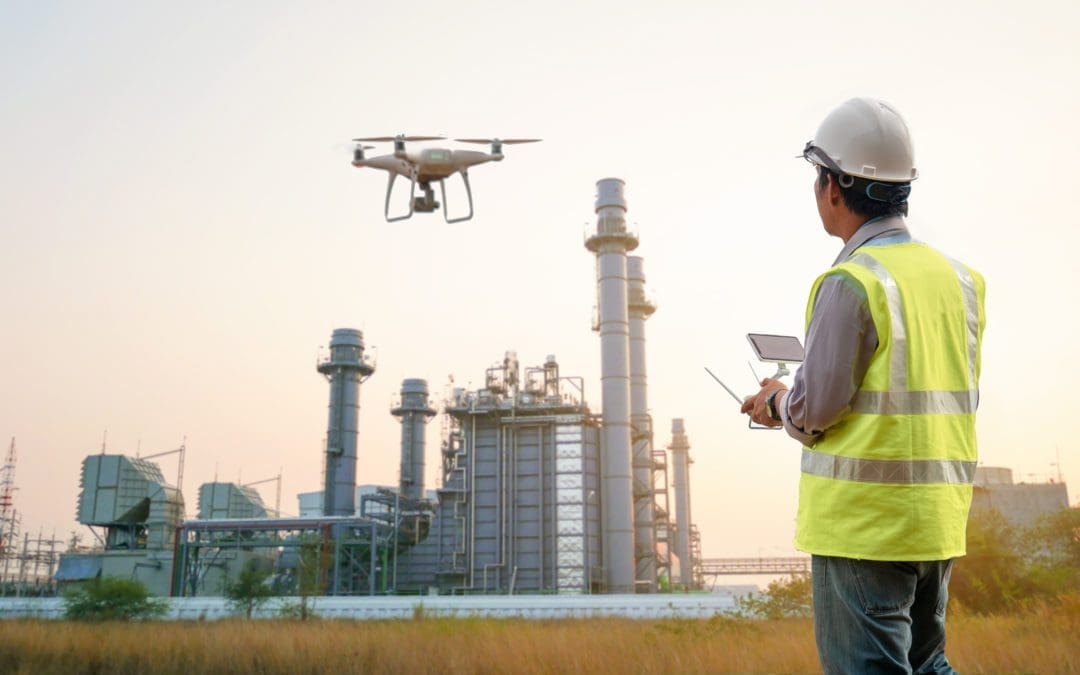
Drone inspection is used to effectively gather aerial imagery of difficult to inspect areas, accelerating visual inspection while delivering superior results at a reduced cost.
Potential Pitfalls When Implementing a Drone Inspection Program
Drones are undeniably revolutionary in the oil and gas inspection landscape. However, like any technology, their integration comes with a set of challenges that businesses must recognize and navigate. Below are a few of the potential pitfalls that companies might face when implementing a drone inspection program:
Regulatory Challenges – Airspace
Drones operate in an airspace that’s governed by a myriad of regulations. In many regions, there are restrictions on flight altitudes, no-fly zones, and specific permissions required for commercial use. Ensuring compliance can be a complex and time-consuming process. Another requirement is that to operate a drone on commercial property, drone pilots must be certified by the FAA (FAA Part 107 license).
Data Management
Drones can capture massive amounts of data in a single flight. While this is an advantage, it can also lead to overwhelming amounts of information that need effective storage and analysis. Without an efficient system or platform to manage this data, crucial insights might be overlooked, or the data may simply be inaccessible to those who need it. The majority of oil and gas enterprises store their visual data in dedicated software with a centralized data warehouse (nearly 90%), while the rest still store that data on a shared drive. Unlike IoT sensor data which can be quickly analyzed to gather insights, visual data consists of individual, unique images and video, making it very time-consuming to analyze and review. For this reason, nearly all companies using drones for visual inspection are using either an in-house, purpose built software for analyzing their visual inspection imagery (35%), or a third party software like Optelos (64%). In the drone analytics market, Optelos is one of the recognized leaders in visual data management.
Drone Operations Training and Expertise
Operating a drone, especially in complex environments like oil and gas facilities, requires specialized skills. There’s a learning curve involved, and companies need to invest in training their personnel or hiring experienced drone pilots. As noted above, commercial drone pilots must also be certified by the FAA to ensure safe operations in accordance with local and federal regulations. For enterprises that aim to use 3D Digital Twins for conducting asset inspections or site management, these pilots require extensive training to capture the imagery in a prescribed manner to support effective photogrammetry model construction.
Technical Limitations
Despite their advanced capabilities, drones do have limitations. Battery life can restrict the duration of inspection flights, which is reduced by cold temperatures. Drones also face challenges operating in extremely windy and rainy weather conditions, limiting their operational days. Further, daytime operation is another limiting factor when collecting RGB imagery (some sensors are not limited by nighttime operations, such as thermal and LiDAR).
Integration with Existing Systems
Companies in the oil and gas sector often have legacy systems in place. Integrating drone-captured data with these existing systems can be challenging and might require additional software or platform solutions. Use of a visual data management platform such as Optelos solves this issue with open APIs which enable effective systems integrations without the use of IT personnel.
Public and Environmental Concerns
While drones are relatively less invasive, they can sometimes raise concerns related to noise, privacy, and potential disturbances to local wildlife. Ensuring that drone operations are environmentally sensitive and respectful of local communities is essential.
While drones offer transformative advantages, it’s crucial for companies to approach their adoption with a clear understanding of potential challenges. Strategic planning, continuous training, investment in the right technologies, and a commitment to ethical operations will be key in ensuring that the implementation of drone inspection programs is successful and sustainable.

Oil and gas drone inspection software enables not only systematic and predictable storage of unstructured visual data, but also includes analysis and measurement tools for working with imagery and 3D models.
How Optelos’ Visual Data Management Solution Augments Drone Inspection Programs
In the vast world of oil and gas inspections, drones have emerged as technological marvels, capturing massive amounts of detailed data. However, the real challenge and opportunity lie in how one manages, analyzes, and harnesses this data to drive actionable insights. Enter Optelos, a leader in visual data management. Let’s dive into how Optelos supercharges drone inspection programs in the oil and gas industry.
Seamless Data Integration
One of the fundamental challenges with drone inspections is the sheer volume of data collected. Optelos simplifies this by systematically aggregating and organizing the unstructured visual data, transforming it into a searchable and shareable database.
AI-Driven Analytics
Optelos is at the forefront of leveraging AI for inspections. The platform’s AI capabilities enable automated processing and analysis, such as detecting pipeline corrosion or prioritizing methane leaks, which drastically reduces the time needed to identify and address potential issues.
Enhanced Collaboration
With integrated data viewers, Optelos ensures that complex 3D models and CAD files of storage tanks, oil rigs, and refineries are easily accessible, fostering better collaboration among inspectors, site managers, and compliance personnel.
Precision and Accuracy
By using hi-res 3D Digital Twin models, Optelos allows engineers to make precise measurements and complete detailed analysis without a physical site visit. This “desktop engineering” is invaluable for pre-project scoping and detailed analysis in support of turnaround programs.
Regulatory Compliance Reporting
Optelos ensures that all inspections are not just about asset health but also about adherence to standards. Features like Ground Level 360 Imagery support required OSHA NEP compliance reporting, providing visual documentation to validate that equipment meets specific operating standards.
Streamlined Workflows
Linking Optelos with popular platforms like ServiceNow, Salesforce, and Microsoft Dynamics means that any detected defects are geolocated and integrated directly into ticketing and dispatch systems. This streamlines and automates the workflow, enhancing the overall efficiency and responsiveness of the inspection process.
Enhanced Inspection Reports
The platform’s patented algorithms utilize metadata to organize and correlate relevant UAV asset files, allowing for more comprehensive reporting on systems such as piping, storage tanks, and flare stacks.
In essence, while drones are reshaping the way inspections are conducted in the oil and gas sector, Optelos acts as the backbone that makes sense of the vast data these drones collect. By providing a platform that is not only robust but also intuitive, Optelos ensures that companies can fully capitalize on the benefits that drone technology offers, marrying the future of inspections with the intelligence of today.
Conclusion
The oil and gas industry, known for its vast operations and extensive infrastructure, is undergoing a technological renaissance with the integration of drone inspections. This new technology promises unprecedented levels of detail, efficiency, and safety, revolutionizing the way we conduct and process inspections. However, the benefits of drones are most profoundly realized when coupled with powerful data management solutions, like the one offered by Optelos.
Drones capture the visual story of assets, but it’s platforms like Optelos that interpret, organize, and narrate this story in a manner that drives actionable insights. From ensuring regulatory compliance and enhancing team collaboration to optimizing workflows and leveraging AI-driven analytics, Optelos has proven to be an innovative leader in the drone inspection industry.
As the industry moves forward, it’s clear that the synergy between drone technology and advanced data management platforms will define the future of oil and gas inspections. Companies that strategically embrace and integrate these innovations will undoubtedly position themselves at the forefront of efficiency, safety, and operational excellence in the years to come.