Telecoms are realizing efficiency & accuracy gains in cell tower inspections and site assessments through asset digitalization, AI analysis and workflow automation
Ensuring the precision and accuracy of cell tower records is of paramount importance to cell tower owners and operators performing cell tower inspections. It is often a struggle to get the data needed to quickly diagnose and solve cell tower problems, leading to potential problems such as inaccurate equipment placement, structural integrity issues, and degraded cell tower RAN performance.
Cell tower assets are built out and maintained by multiple companies and teams over the course of the tower’s lifetime, and accurate record updates of structural changes to the tower infrastructure and antennas are often not reliably made in the appropriate asset databases. Our extensive experience working with global carriers, contractors and tower owners has revealed that the majority of records for cell tower sites reflect data hygiene issues / inaccuracies which may impact RAN performance or the structural integrity of the tower:
- As-built does not match design spec: 75% of sites
- Antenna skew errors: 65% of sites
- Structural errors to as-built: 80% of sites

Tower owners, operators, and contractors are turning to new visual data management solutions to provide the accurate and reliable data needed to support efficient cell tower maintenance and technology rollout programs. The availability of accurate and up-to-date site assessment data streamlines operations, enhances decision-making, and significantly reduces operational costs. By leveraging new visual data management systems such as Optelos in combination with drone data collection, 3D digital twin point cloud models and AI technologies, companies in the telecom industry are revolutionizing the process for how to inspect, manage and maintain their tower assets, yielding significant cost savings and operational efficiencies.
One Tower, Multiple Stakeholders
Regardless of who owns the cell towers, the primary concerns for each party involved in cell tower site assessments revolves around data accuracy and availability:
- Tower Owners: Seek the most accurate and complete information to effectively track utilization rates and market actual available space, ensuring they can maximize return on investment.
- Telecom Operators: Require a detailed understanding of the inventory of installed equipment and configuration to ensure optimal performance, space efficiency and understand available mounts, power and load for desired RAN enhancements.
- Contractors: Require comprehensive surveys of the asset to accurately understand project parameters, tower condition, current asset status, available mounts, rack space, and potential obstructions that may impede work.
Recent advances in artificial intelligence and machine learning (AI/ML), combined with drone-based data collection techniques and effective visual data management, have allowed telecom providers to dramatically improve the accuracy and efficiency of their cell tower inspection programs while simultaneously reducing costs.
These concerns underscore the need for precise, organized and reliable data to streamline decision-making and operations.

Data for all aspects of a cell tower inspection are organized per your customized workflow, enabling streamlined data access for improving collaboration and process efficiency.
The Process: Creating an Accurate Database of Site Assessment Data
In order to digitally transform the inspection and site assessment workflow, the digital data must be carefully captured by qualified FAA Part 107 pilots in order to render precise, accurate and reliable 3D digital twin models. To read more about how Optelos captures this data differently, visit our page on Drone Inspection Services. The steps in creating an accurate digital record of cell tower assets are as follows:
- Cell tower structural data capture: The modern method for completing site assessments starts with aerial drone data capture of the cell tower structure. Trained and FAA certified pilots travel to the cell tower location to capture all the necessary imagery required to build a model.
- Interior space data capture: Leading telecom providers may also capture interior cabinet and shed imagery (photo, video) to provide remote engineers with additional information to support maintenance operations and diagnostics. This imagery is used to visually verify available space in power racks, current installed equipment, equipment label tags, asset physical status, site security, cable run placement and more.
- 3D Point Cloud model construction: Optelos Image Analysts use the captured tower imagery to build the 3D Digital Twin point cloud models. These models are typically accurate to 1 cm, but can be made to be accurate to 1 mm with additional data capture, time and precision data capture attention.
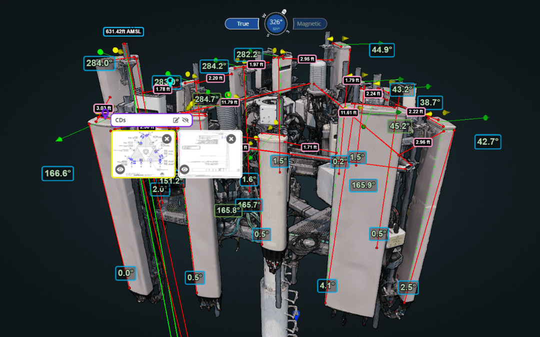
- Measurements and Analysis: The point cloud models, constructed of millions of data points, are self-referencing and can be used to complete precise measurements on the models. The digital 3D model is then compared with existing documentation to pinpoint discrepancies to determine whether the tower is constructed as specified by comparing construction drawings (CDs) to the as-built tower model. The use of AI-assisted analytics can automate the identification of asset inventory, orientation, and placement, as well as conduct mount analyses and wind & ice load calculations on the tower body, appurtenances and other structures.
Leveraging Visual Data and Workflow Automation to Streamline Cell Tower Site Assessments
Combining 3D digital twin models with AI analysis and effective visual data management significantly enhances the efficiency and accuracy of cell tower inspections. By automating and streamlining cell tower inspection workflows through standardized data analytics, automated AI analysis and visualization techniques, engineering teams and maintenance organizations have successfully reduced the time to complete site assessment meetings by 60%. By standardizing the data collection, analyses and having a trusted visual resource (the annotated 3D digital twin model) that displays the actual state of the tower and all installed equipment, it has virtually eliminated project unknowns and finger-pointing. The main applications in cell tower inspections include:
Determining Accurate Status of Leasing Space and Assets
Digitally transforming the workflow enables tower owners and operators to maintain up-to-date records of all equipment and configurations on a tower in a single step. This clarity supports better lease management and asset utilization by providing visual proof of the current state of the installed equipment, space available, presence or absence of encroachments, mount availability and asset inventory. When selling tower assets, the digital twin is visual, auditable proof of the assets available and transferred at time of sale, removing any doubt and legal risk from misunderstanding or conflicting documentation.

Workflows can be digitalized and streamlined within Optelos. Here, a digital twin of the as-built cell tower is compared to CAD drawings to verify the RAD center has been built as designed for optimal performance and coverage.
Proper Scoping and Site Assessment for New Technology Deployments
Utilizing digital twin models and digital workflow management facilitates precise planning for the integration of new technologies for pre-construction site assessments, ensuring projects are properly scoped and done correctly the first time. When initiating a new technology deployment, an accurate understanding of the current state of the asset is critical to be able to properly plan and execute the project. Aerial, ground and walkthrough data capture can help in many ways:
- Tower data capture with 3D model construction: Verify equipment location, orientation, placement, adjacencies, available mount locations and cable runs. Ensure placement and orientation of antennas match the initial RF design specification and CAD drawing.
- 360 ground capture: Validate access to the site, environmental/vegetation encroachments that will hamper required installation equipment placement (e.g. cranes/cherry pickers), location of security fencing, adjacent buildings and heights.
- Walkthrough data capture: Matterport data capture in the shelter can also provide valuable information to speed up and ensure the success of an installation. Capturing a complete array of shelter and cabinet images (including equipment tags) can show availability of rack space, power availability, installed equipment, cabling, model information and floor space for new racks.

Walkthrough data capture enables remote 3D visualization of the configuration, placement and available space within the shelter. Breaker panels and cabinets are opened to allow gathering all relevant imagery.
Automating Analysis with AI
Once aerial data is collected and a 3D model constructed, automated AI analysis of the 3D model can speed the processing of the data to verify many aspects useful for site assessments and asset management. With integrated AI capabilities and workflow automation capabilities, the Optelos platform can streamline and perform the following types of analyses valuable for cell tower site assessments:
- Mount analysis (mount capacity on as-built or as-designed model)
- Data reconciliation (equipment makes & models, mount types and availability)
- As-built vs. as-designed (detected equipment can be compared to the design model)

AI analysis of 3D digital twin point cloud models speeds up and automates many routine but time-consuming analyses, including mount analysis, data reconciliation and as-built vs. as-designed.
“Optelos has been critical in our PIM mitigation project by identifying issues from the desktop and allowing us to share large, detailed 3D models with our distributed turf vendors in real-time to come to agreement and make decisions immediately. We’ve cut our required onsite time by more than 50%.”
Manager, Tier 1 Telecom Provider
Time Savings from Reduced Field Visits and Re-work
Digital twins and detailed data analysis minimize the need for physical site visits, significantly reducing the time and costs associated with travel and subsequent adjustments. More importantly, it reduces the need to multiple site visits for collecting data missed the first time, and enables desktop engineering to verify space availability for installing spec’d new equipment for expansion or repair within acceptable tolerances, before ever leaving the office.
RF/RAN Optimization
RF engineering can use the digital twin models to verify the RF design was properly implemented and built to specification (antenna placement & orientation of the RAD center). The RAN group can evaluate the impact of the overall network and performance for each individual cell tower. The ability to house all CAD drawings, 3D models, shelter photos, inventory, inspections and other required documents in one location can speed up collaborative work dramatically. One major telecom provider reported that site assessment team meetings were now 60% shorter, and decisions were made in the meetings, versus leaving the meeting with a series of “go gets” for required information.
Post-construction Audits
The post-construction audit workflow is also similarly streamlined, enabling quick verification that work was completed per the design specification by comparing the digital twin to the CD. If work was not completed as designed, the discrepancies can be quickly identified within the warranty period, saving time, repair costs and improving service delivery.

3D digital twin point cloud models of a cell tower site can be used to verify all aspects of a tower’s current physical condition, including security fencing, vegetation encroachment and accessibility.
Summary
The article emphasizes the critical importance of maintaining accurate cell tower records to ensure optimal performance, safety, and revenue generation in the telecommunications industry. It highlights common data inaccuracies and structural errors in cell tower records, indicating the need for improved visual data management workflow digitalization. By leveraging technologies such as 3D digital twin models and AI analysis, companies can streamline inspections, reduce operational costs, and enhance decision-making. The process involves capturing aerial drone data, constructing 3D models, and conducting precise measurements and analyses manually and automatically using integrated AI tools. These advancements facilitate accurate site assessments, leasing space management, technology deployments, RF optimization, and post-construction audits, ultimately leading to significant time savings, cost reductions, and improved operational efficiencies for telecom service providers globally.